Sunday, October 21, 2012

Father / Son Trip 2012


Day One: 9.3
Mt. Sterling Trail 0.5
Long Bunk Trail 3.6
Little Cataloochee Trail 4.1
Palmer Creek Trail 0.8
Pretty Hollow Gap Trail 0.3
Campsite #39
Day Two: 8.4
Pretty Hollow Gap Trail 0.3
Palmer Creek Trail 3.3
Balsam Mt. Road 0.7
Balsam Mt. Trail 4.1
Laurel Gap Shelter
Day Three: 8.7
Balsam Mt. Trail 0.2
Mount Sterling Ridge Trail 5.8 to tower
Mt. Sterling Ridge Trail 0.5
Mt. Sterling Trail 2.2
Total Miles: 26.4

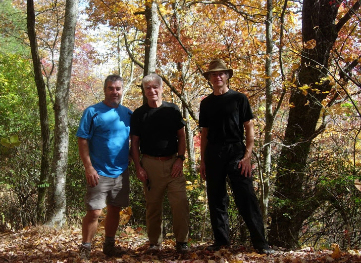
We started out with the family get-to-gather at the ponderosa.  The ladies didn't wait for us to get on the trail this year.  They started early heating up the credit cards.  Steve and Dad were doing chores before I arrived and somehow I missed out on the work.  We ate lunch and discussed how we could make a simple hike difficult.  We had two hikes on the books this year and they had settled on a loop hike.  I had figured a good loop with a big climb on the front end and the rest down hill.  Who would have thought about doing it backwards.......well I mean besides Dad?

We headed out on Thursday for the Mt. Sterling Gap trailhead.  After we shook off Dad's van racing, we hiked up the Mt. Sterling trail to the Long Bunk trail.  The first people we passed were an older couple who were doing a sixteen mile day hike.  That was only about the same as our first two days.  They were the heroes today.  When we got to Little Cataloochee trail we got to tour a few buildings and grave yards.  They have restored a couple of cabins and a church from a former life.  It is always fun to see history in the Smoky's.  Somewhere along this trail Dad mumbled something about not remembering this trail being so steep.  As we were climbing we heard and saw two Hawks flying overhead.  That was followed by an owl doing some talking.  Towards the end of the trail, on a down hill section, a turkey walked across the trail dragging his beard.

Just before we got to our campsite we met the older couple again heading down the trail.  They might have made it out before dark, but not by much.  When we got to camp there was a woman camping alone.  She went by the trail name "Sunshine".  She visited with us around the campfire that night.  She had a history of hiking including a thru hike of the AT.  She was a nurse from the Asheville North Carolina area.  She was going to meet up with her boyfriend at the Laural Gap shelter the next evening.  Surprise, that was where we were going.  We had a clear night with lots of stars. 

Sometime in the night a very strong wind came through.  I woke to my tarp beating my hammock.  I heard Steve getting up to adjust his tarp.  I got up to cover my pack as I figured the rain would be blowing hard soon.  The wind died out and later we got a light rain which was all done by the time we got up.
We got up and headed out after breakfast.  Sunshine caught up to us and hiked with us for a time before heading on.  For some reason there was alot of climbing today.  We hiked up into the clouds and the scenery was limited.  We had a good climb up to our shelter.  When we got there Sunshine and her boyfriend Chris were there.  We did some searching and came up with enough fire wood.  Slowly but surely people started showing up.  We ended up with 12 in the shelter and three pitched a tent.  We were entertained with lots of stories and with a beginner hiking trio.

We had two retired police officers from Atlanta to tell stories.  They had a son in law with them.  The three hikers from Chicago were fresh to hiking.  We tried to help them out with some tips for their next trip starting with some real clothing.  They had eaten granola and jerky for the first two days.  Tonight they were going to try Mountain House meals.  They pulled out their two liter nonstick stove top pan and started trying to make a fire.  Someone finally felt sorry for them and heated some water on the stove for them.  They were trying to save weight by not bringing a stove.  The other one pulled out a full size bottle of Gold Bond to cover his feet.  They had blisters on their blisters.  They pulled out their pocket knives to use as spoons, but they really were impressed with Mountain House.

After a night of rolling from one sore spot to the next, like shelters make for some reason, we got up and headed out.  We hiked the Mt. Sterling Ridge trail up to the tower on Mt. Sterling.  We got some good views from the tower and then ate lunch at the base.  We saw another couple as we headed back to the Mt. Sterling trail and down to the car.

We stopped for a celebration ice cream in Wears Valley and headed home for the pizza celebration at the ponderosa.  After dinner we had a serous card game while we waited for Marco and Natalie to show up.  Then we celebrated their wedding with another party.

The next day we headed out to Metcalf Bottoms for a hike and picnic.  Lots of people were out enjoying the wonderful fall colors of the mountains.  We enjoyed the love of family.

Pictures:

Sunday, October 14, 2012

Cataloochee, Smoky Mountains


Rough Fork Trail 2.9
Caldwell Fork Trail 1.5
Campsite #41
Day one total: 4.4 Miles
Caldwell Fork Trail 2.1
Boogerman Trail 4.1
Caldwell Fork Trail 0.8
Road walk 2.7
Day two total: 9.4
Total Miles: 14.1

Lora and I went to Cataloochee in the Great Smoky Mountain National Park.  This was the first time in that area for both of us.  She wanted to see the Elk and old growth trees.  We went in on Cove Creek Road and the colors were wonderful.  On the way in after you pass the campground, there is the Ranger House, a church, a school house and another house that have been restored.  When we got to the fields the road was lined with cars and people setting out in lawn chairs.  It looked like they where waiting for the Elk to be released.  We drove to the end of the park to our trailhead for the Rough Fork Trail.

After we packed up, we headed into the woods and within the first hundred yards we had seen six Elk.  The first three were laying by the side of the trail.  It was funny to think that all those people were in the fields waiting.

We did do a tour of the Woody house, another restored structure on the trail, on the way through.  Campsite #40 is a smaller campsite covered with large downed trees by the creek.  It has three different small sites.

We got to see some large trees, but also an incredible large poplar tree off the trail before campsite #41.  Campsite #41 is a large campsite along the creek.  There were four other groups in the campsite before we got there.  We got to listen to an owl during the evening hours while setting around the campfire.  We had a very peaceful night with lots of stars.

The next morning we headed out again.  We got to see more large trees, many rock walls, and old home sites.  There is one section of the Boogerman trail that has numerous large old growth trees.

When we got back to the valley we got to see two different herds of Elk and a flock of turkeys.  Cars were once again parked all along the fields with people in lawn chairs.  This time they did have something to look at.  We got in the car and then took the Mt. Sterling road on the way out.  It is a long mostly one lane gravel road that curves through the mountains.  A very beautiful trip.

Pictures:

Sunday, October 7, 2012

Soddy Creek - Cumberland Trail

After church Lora and I decided to hike on the Cumberland trail.  We were already in Soddy so we headed up Hotwater road to the trailhead.  We headed South on the trail through the old mining area.  We didn't get,   but a couple of miles in and my foot started bothering me again so we headed back.  It was a beautiful day to be on the trail.

Pictures:

Saturday, October 6, 2012

Honey Creek - TTA


TTA hike with Upper Cumberland. Pete K. was our leader for the Honey Creek Hike. I drove thru fog, mist, sprinkles and cloudy skies to the trailhead. It was a cool fall day. 12 hikers set out to see the best that Big South Fork has to offer. It stopped sprinkling before we started.

We started at the overlook, and then climbed down the ladders to the trail. I took my crocs just in case the creek crossings were high. We found a couple of places that the trail was too muddy and the rocks too slick to climb down, but not to worry….Pete had a rope! He tied off to a tree and we used it to descend. I didn’t need my crocs, the creeks were low, just rock hopping.

We had lunch on an open area of rock. We were amazed at the rock bluffs on this trail. Such a cool area to hike. The sun finally broke thru and warmed us up a little. You have to watch for the blazes on this trail, some are painted on the rocks you have to climb thru and around.  This is the 4th time I’ve hiked Honey Creek and I always manage to lose the trail. Pete kept us on track and we climbed back up the ladders to the overlook to finish the hike. It was great. I love this trail.

I wanted to stop in Allardt for the Pumpkin Festival. I got right to town and the highway was shut down for the parade. I watched folks get out of their cars and walk up to the street to watch the parade. This is a main highway! I got out and walked up to the police officer stopping traffic to let the parade out of the side street, and said “so in this town it’s alright to park my car in the highway and leave it to watch the parade?” and he says “No ma’am, it’s not ok” and I asked how long we would be sitting still, “about 45 more minutes” he said. It only took about 15 really when we started moving. I had to go around 2 vacant cars, wonder where those folks were? hmmm. I parked in a field and walked thru the craft areas. SO much BBQ cooking, all pork, no chicken. So I got a Nathan’s hot dog smothered with grilled onions and mustard and a big glass of fresh squeezed lemonade. Mmmmmm.

Coming into Pikeville I saw the sign for the Harvest Festival happening today. I missed it, but caught the last few minutes of the music. Cody McCarver was singing, glad I stopped by.

It was a great day.


Pictures: